ATOVS Reader
AVHRR Manager
BUFR Viewer
CHLO Viewer
CMA Viewer
DDE/SDR# add-on
Defrag NPP
DWDsat HRPT Viewer
GeoSatSignal
GOES ABI Manager
GOES-15 netCDF
GRIB Viewer
Ground Map
HDF Viewer
HRPT Reader
HRPT samples
Kepler Updater
Automating LRPT
LRPT Processor
LRPT signal
Metop LSA Viewer
Metop Manager
MODIS L1 viewer
MSG Data Manager
NOAA HDF Viewer
SatSignal
Sea-Ice & SST Viewer
Sentinel-2
Sentinel-3
WXtrack
| |
Weather Satellite Tools from SatSignal Software
I am currently writing software for weather satellites with the aim of automating as much as possible, and allowing you to extract the maximum
possible from the available data. A more detailed
technical description of some of the earlier software is also available on-line.
This software should run on any current version of Windows (Windows-7 or later), including the 64-bit and Server versions. The Apple Mac OS
is supported through virtual machine software and the WINE add-on can be used
for Linux. There is a partial list of data available from EUMETSAT here,
together with a guide as to which data is handled by which of my programs.
The Tools
- ATOVS Reader - reads the
thermal sounder and microwave radiometer data available either from the CLASS
archive service or from the EUMETSAT EARS
service (retransmitting polar orbiting satellite data for Europe), and
presents a remapped false-colour display of the 40 available channels.
- AVHRR Manager -
decompresses the NOAA-19, Metop-A and Metop-B AVHRR data received from multiple stations on the EUMETCast stream, re-assembles
that data into composite files, handles out-of-order data and short
segments, provides an optional audible warning of new pass and new segments,
and provides an attractive quick-look display of current segment and pass
data. Includes a browser for easy access to thumbnail or AVHRR data
using the HRPT Reader.
- BUFR Viewer - a program to visualise the wind data available on the EUMETCast
data stream. This includes air-motion vector data (derived from
Meteosat-9/10), wind data from the scatterometers on the ERS-2 and Metop-A/B
satellites, and polar wind data.
- CHLO Viewer - a
program to visualise and read out values of ocean chlorophyll concentration
data sent over EUMETCast and downloaded from the Ocean Color Web site.
- CMA Viewer - a program to visualise the CMA (China
Meteorological Administration) data sent over EUMETCast, including Cloud Type Analysis,
Cloud Total Amount, Relative humidity, Outgoing Long-wave Radiation, Precipitation Estimate,
Black-Body temperature and Total Precipitable Water-Vapour. The
program can be used interactively or in command-line mode for completely
automatic operation for saving the data as images.
- DWDSAT HRPT Viewer -
program to visualise the calibrated and rectified HRPT data from
various NOAA satellites covering the central European region, and provided as part
of the free DWDSAT
service broadcast over EUMETCast.
- GeoSatSignal - a tool for geostationary weather satellites, which can
join images, make false-colour images by combining various data channels, rectify images to
various standard projections, overlay weather charts, and animate a sequence of images to make your own weather movie.
You can process image or digital data from either the EUMETCast
service, your own receiver, or
download data from the Internet if you prefer. The unsupported AutoGet
or Francis Breame's getCharts
may be used to get Internet data automatically.
- GRIB Viewer -
visualise the cloud data (including cloud-top height), clear-sky
reflectance, and DWDSAT
data broadcast over EUMETCast, and the DPDS
data from the UK Met Office. More data sources may be added for registered
users.
- GroundMap - rectifies
HRPT or APT images from NOAA satellites to standard map projections allowing
for subsequent processing e.g. combining several passes to make a wide-area
image, using data with other programs etc. The software can remap geostationary data as well.
- HDF Viewer - visualise
the Land Surface Analysis SAF
European data
broadcast over EUMETCast and
African and American data available from the LSA-SAF
Web site. This data includes the down-welling flux separated into
long-wave and short-wave components, and land surface temperature data.
- HRPT Reader -
processes HRPT data in a variety of formats (including from the EUMETCast
EARS AVHRR service) and
can produce false-colour images and APT thumbnails. Individual sensor
channels can be viewed or combined to RGB channels, with temperature
calibration and geographic overlays. You
can process data from your own receiver, or data obtained from the Internet,
so no receiver is required. Includes the ability to remove the scanner geometric
distortion from raw HRPT images.
- Kepler Manager - can
provide completely automated Kepler management for registered users of the
Space-Track Web site. The registered version (or if you have the
registered version of WXtrack) allows hands-off update scheduling.
- MapToGeo - can
reprocess Plate-Carre� projection image data into standard geostationary
mappings to form backgrounds for live geostationary thermal data.
- Metop Manager - a
new program to automate management of the global, continuous, world-wide
coverage AVHRR
data from Metop-A as broadcast over EUMETCast.
- MSG Animator -
provides real-time monochrome or false-colour animations of Meteosat-8/9/10 and
foreign satellite data images from the MSG Data
Manager with four or more (depends on your PC) simultaneous animations from
thirty available. You can select which
channel and regional subset to use, and boundary overlay and contrast
stretch options are included. Animations can be time-selective, and
saved as standard .AVI files. For use in a public display environment,
the program can automatically switch between the available animations,
making it ideal for a reception or office entrance area. For use in a
museum or space-centre environment, input from a touch-screen is supported
allowing visitor interaction.
- MSG Data Manager
- provides data management of the vast flow of
Meteosat-8, 9 and 10 (Indian Ocean, Europe & Africa), GOES-East & GOES-West (Americas),
Chinese FY, Japanese Himawari-8 (Asia) and more data, enabling you to
automatically delete the HRIT source data, decode and process the data into images, and
select which channel images to keep. Data is saved in industry
standard image formats, not proprietary, and the program can function with
networks as recommended by EUMETSAT. More
info about acquiring MSG data.
- NOAA HDF Viewer -
Program to display Australian Geoscience data, all five AVHRR HRPT channels
at 1 km resolution over Australia, with a variety of derived data such as
vegetation, temperatures, dust/ash and fire possibility. New program
still under development.
- PassControl -
automatically tune your APT receiver (RX2, R2FX) to pick up NOAA passes you
schedule.
- SatSignal - NOAA APT/Meteor/Okean/Meteosat/GOES/GMS/MTSAT-1R wave file to picture demodulator.
Decodes saved wave file or 2-channel NOAA image to pictures with false colour,
overlays and
temperature readout etc. Read more about
SatSignal. Includes SatBatch
an automated driving program for
SatSignal and WXtrack to decode a whole folder full of wave files from a day's or a week's
collection.
- Sentinel-2
- I offer a couple of programs for Sentinel-2 which will process the three
16-bit JPEG 2000 images you can download from the EOS Web site into
high-quality full-colour JPEGs suitable for general use. The main
program is Sentinel2toJPEG which does the three JPEG 2000 to on JPG
conversion, and the second is an ancillary program - ThreeJP2toPNG48 - which
converts the three JPEG 2000 files into a single 48-bit PNG or TIFF file for
faster process. These programs are presently in beta.
- Sentinel-3
- This page describes reception of the Sentinel-3 data over EUMETCast, and
offers scripts using Python and other software for automated processing of
the data to full-colour JPEG images.
- Sea-Ice & Viewer -
provides three false-colour interpretations of the sea-ice and
sea-surface-temperature data available
over the EUMETCast broadcast system and the full north-polar and south-polar
data from the OSI-SAF Norwegian Web site.
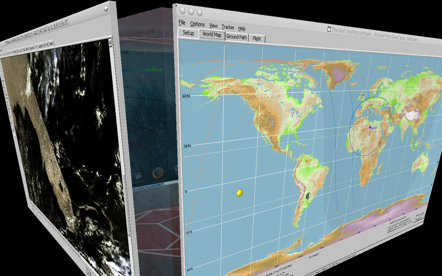
- WXtrack - Satellite orbit, ground track & ground
image prediction. Drives trackers. Also available as an Active-X
component for other languages. Read more about using
WXtrack. Now available in 3D!
As I am continually revising these programs, I also provide a page of updates to show the status of all my software. You can
bookmark this page and get automatic notification by e-mail of any updates if you
wish. There are free versions of all my satellite programs, but I will
obviously feel more encouraged to add new features if you choose to make a small
contribution by registering the program to obtain support. I'd rather spend my time enhancing the software than answering
questions that are already covered in the ReadMe or Help files, so please do check
these out first.... There is a free, self-help group that you can join
here: https://groups.io/g/SatSignal where other users of the software can be contacted and ideas for updates are
discussed.
I don't currently offer any software for the ENVISAT
project, but I can offer to write other satellite decoding and display
software for your own special needs.
As many people want more than one item of software, I have
provided two suites of programs, one suitable for geostationary data over
EUMETCast, and the other for polar orbiter data over EUMETCast.
- The
MSG Toolset Plus suite includes:
- The MSG Data Manager - data decoding and management
- The MSG Animator - multiple, single-channel animations
- GeoSatSignal - multi-channel, reprojected images and animations
- The
HRPT Toolset suite includes:
- The AVHRR Manager - data decoding and management
- The HRPT Reader - data display
- GroundMap - image rectification
- WXtrack - orbit prediction
- The Kepler Manager - Kepler management
- The
HRPT Toolset Plus suite includes:
- The AVHRR Manager - EARS/AVHRR data decoding and management
- The Metop Manager - Metop/AVHRR and NOAA-18/GAC data decoding and management
- The HRPT Reader - data display
- GroundMap - image rectification
- WXtrack - orbit prediction
- The Kepler Manager - Kepler management
Publishing data
Please respect the publishing requirements of the different
data sources when using my software.
Guidelines
on publishing EUMETSAT data are here.
In Dutch
For an overview of my software please see:
http://www.meteo-maarssen.nl/software.html
In French
For a brief summary in French, please see:
http://www.f6bek.fr/
=> Documentation (http://www.f6bek.fr/perso-23417.htm)
What is the Mac Support?
These programs have been developed for use on Windows, but as they use no undocumented
function calls they should run under Parallels
Desktop on Intel-based Macs.
So far, both GeoSatSignal and the MSG Animator are reported by Nick Hewgill to function
well. Nick further reports:
Also I have done some other tests with a Macbook with Mac OS X v10.5 2GB
ram 120GB hard disk using bootcamp, I have tested the following (all latest versions):
AVHRR Manager
GeoSatSignal,
Metop Manager,
MSG Animator,
WXtrack
All work fine.
Jiro Yamamoto reports that major software, including HRPT
Reader, WXtrack, GeoSatSignal and GroundMap, is working without any problems (quite
stable !) under his Parallels Desktop 3.0 for Mac.
Alejo comments: Hi
David, perhaps you knew it but here is a screenshot of your nice software running under
Mac OS X Leopard
i only lack 2 things that i became used to from SatScape (crashing is not one):
1. speech synthesiser announcing the passes
2. the radio freqs on the main window info.
Let me know if you like to know more about how to get it to run, it
was very easy.
|
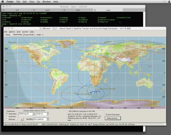
(Click for a larger image) |
You can also try the free VirtualBox
software.
The software should also work correctly under the Microsoft
Virtual PC (note that only Windows can host this software).
What is the Linux Support?
These programs have been developed for use on Windows, but as they use no undocumented
function calls they should run under Linux using the Wine compatibility layer.
So far, the ATOVS Reader, the HRPT Reader and SatSignal are reported to function well, with
good success for WXtrack and the MSG Data Manager. They should also work under
virtualisation software such as Parallels
Workstation or the free VMware or VirtualBox.
| Jeff Kelly comments:
Had some time today to play with Wine on my Celena Linux Mint (ubuntu)
distro. Both WXtrack and the HRPT Reader all ran fine with all the testing I
have been able to do. Basically you just need to place wine in front of
the path to the program exe and it starts right up.
|
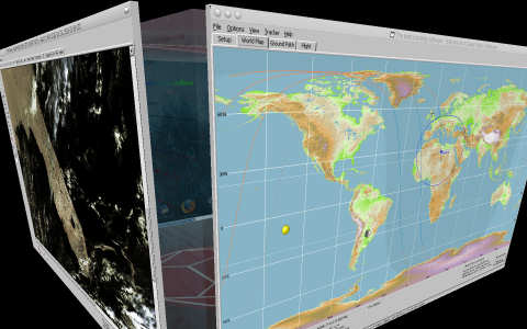
(Click for a larger image) |
Les Hamilton comments that he has installed the Runtime Library using 'Wine', and has now successfully run SatSignal,
the HRPT Reader and WXtrack under Ubuntu Linux, via the Wine 1.00 emulator.
Further tests have shown that some of the more recent
programs - the ones which require a hardware fingerprint -may need a
special-to-order version for WINE, as some of the advanced APIs required
are missing from some versions of WINE, although this has not been a
problem people have reported recently.
|
Which tools do I need?
I am sometimes asked which of my tools does what job, and where they might fit
into a typical Weather Satellite receiving station.
Geostationary data:
- If you have no receiver, but still want to process images, or
if you want to make animations, GeoSatSignal
is for you. Using data off the Internet it is possible to make movies of
the weather data for the many parts of the world, including Japan, Australia,
the USA and Europe. You can choose what data to download and how often
using your own preferred Internet tools, or an automated program available with
the package or elsewhere.
- For the new Meteosat-8/9 European geostationary satellites, the MSG
Data Manager decodes files received by your satellite
dish, DVB card and software into images handling both the HRIT, LRIT and
Foreign Satellite Data. You can animate the images in real-time with the MSG
Animator, or make false-colour remapped images or animations with GeoSatSignal.
Package MSG
Toolset Plus.
For polar data broadcast over EUMETCast, there are three
possibilities.
-
For the EARS-AVHRR data (near-real-time NOAA-17 and NOAA-18 covering an extended
Europe), the AVHRR
Manager will produce single-pass combined files for the segments sent over
EUMETCast. The HRPT Reader program will visualise
the resulting files, and GroundMap rectify the
results to standard map projections. You may also wish to use the Kepler
Manager to keep your Keplers up-to-date. Most of the functions of this
software can be automated, using simple batch files you develop to meet your own
customised needs. Package HRPT
Toolset.
- For the Metop-A data being sent over EUMETCast since November
2006, you can use my Metop Manager. This data is sent 24 x 7, and provides
continuous, world-wide coverage at 1km resolution - something we have never seen
before. The Metop Manager helps you manage
this great influx of data, and allows you to select regions of the earth for
further visualisation with the HRPT Reader and GroundMap tools mentioned above.
- The free DWDSAT
service offers data from a number of NOAA satellites (e.g. NOAA-15, 17 and
18) pre-rectified to the central-Europe region at a fixed ground
resolution. My DWDSAT HRPT Viewer allows
visualisation of that data, and some false-colour and channel combination
options as well. The DWDSAT data is available as both TIFF files, and
.PL1 files. The latter have a higher resolution, similar to the native
satellite resolution (1km).
For polar orbiting satellites, NOAA, Meteor or Resurs, there
is both the lower-resolution APT data, and the higher resolution HRPT
data.
- For HRPT. My HRPT reader can read HRPT and CHRPT data files in a
variety of formats and produce images including false-colour pictures, as well as
indicative aerosol and vegetation density plots. The program can correct the
image geometry to resemble a normal picture, or you can use my separate Correct
Geometry program (also works with MODIS images). To remap the data to standard map projections, you
can use my GroundMap software. The HRPT Reader
can read files available from the
Comprehensive Large Array-data Stewardship System (CLASS) and the Space Monitoring Information Support (SMIS),
or the data files saved by Timestep, Quorum,
SSB/Orbit and NOAA95 hardware. You will need either to use your own data acquisition
hardware and software, or to download data files off the Internet to use with this
program. You can also read files processed from the EUMETCast AVHRR
broadcasts from NOAA-17, NOAA-18 and Metop-A.
- For APT. Once you have demodulated
the RF signal from your APT receiver, you will typically have a 2400Hz carrier which is
amplitude modulated with the image information. You can use any software you like to
record this signal as a wave file to your computer via the sound card. Personally, I
use Christian Bock's excellent WXSat. Les
Hamilton has provided a Beginner's
Guide for WXSat which I suggest you read.
My SatSignal program will decode saved wave files
and produce images including a 2-channel picture and a false-colour image (for NOAA
satellites). The registered version of SatSignal will also decode 2-channel images
(allowing you to keep the more compact bitmaps rather than original wave files), and SatSignal can add country and state boundaries, gridlines and so forth.
SatSignal should be able to post-process virtually any wave file produced by other audio
or satellite software packages (provided it is in the standard Windows wave file format,
11.025KHz mono) or, with the registered version, any 2-channel image saved in greyscale
BMP, JPG or PNG format.
I need help - where can I talk to existing users?
I have set up a number of groups to put like-minded
users in touch with each other:
- SatSignal
- for discussing my software
- ATVOS
- for the multi-channel microwave and infra-red polar orbiter data
- AVHRR
- for users of the EARS AVHRR service
- DWDSAT
- for users of the DWDSAT service
- Metop
- for users of the polar-orbiting Metop satellite and other polar data
- MSG-1
- for users of the MSG-1 and MSG-2 data, and EUMETCast in general
Tell me more about Remote Sensing
There is a tutorial available at EOS (Earth Observing System) site at
this URL:
http://rst.gsfc.nasa.gov/
GEO - the Group for Earth Observation
You should support the Group
for Earth Observation - a group of mainly amateur enthusiasts with members
spread across the world who communicate via the GEO-Subscribers
self-help group, through regular GEO
Symposia, and through the first class GEO Quarterly magazine - read and
respected across the world. Try joining for a year and I guarantee you will
be hooked for life!
|