|
| |
HDF Viewer
What the users have said:
- The program is a joy to use for both EUMETCast and Internet
data - Douglas Deans.
 Download the HDF Viewer
 Register the
HDF Viewer
- please help support continued development Register the
HDF Viewer
- please help support continued development
What is the HDF Viewer?
The HDF Viewer is a Windows program which visualises the HDF data from the Land Surface
Analysis (LSA) Satellite Application Facility (SAF) LSA-SAF
broadcast over EUMETCast or over FTP from the LSA-SAF
Web site. You can visit the self-help
MSG-1 group to talk with other LSA-SAF users. You can use the program
interactively, or as part of a hands-free procedure to process the data
completely automatically.
What data format does it read?
- LSA-SAF data available from the EUMETCast system (as used for
Meteosat-8/9 reception). This data covers Europe, North and South
Africa, and South America.
- LSA-SAF data available over FTP from the LSA-SAF
Web site.
- LSA-SAF down-welling fluxes and surface temperatures.
- LSA-SAF Albedo (various channels and
wavebands) and snow-cover data.
- LSA-SAF Vegetation products (vegetation cover, leaf area index,
absorbed photosynthetic active radiation, evapotranspiration).
Please note that the files from EUMETCast are sent in a BZ2 compressed format to reduce the bandwidth requirement. If you use my
MSG
Data Manager software, this can automatically unzip the data for you. The
HDF Viewer will automatically unzip BZ2 data on-the-fly, otherwise
you can use a BZ2 unzip program.
Sample file names:
S-LSA_-HDF5_LSASAF_MSG_DSLF_NAfr_200905190830.bz2
S-LSA_-HDF5_LSASAF_MSG_DSLF_Euro_200905190000.bz2
S-LSA_-HDF5_LSASAF_MSG_DSSF_Euro_200905190000.bz2
How do I get the data?
The data is free from EUMETSAT and is delivered over the same
EUMETCast system used for Meteosat-8 data. You may need to make one small
change to your recv-channels.ini file to enable data reception. Please
note that editing the recv-channels.ini on a live system may cause a momentary
break in the data. If you have then entry [*] for the channels to receive
you need make no change. The notes below are only a guide - your
particular recv-channels.ini may differ.
Note that this is not the recv.ini file! Please consult your system vendor
before making any changes! Please do not send me questions about
this - please either ask the person who supplied your TelliCast software (e.g. EUMETSAT),
or ask on the self-help MSG-1 group.
Possible changes to recv-channels.ini
You may not need these! |
Before |
|
After |
[EUMETSAT Data Channel 1]
target_directory=received

[EUMETSAT Data Channel 2]
target_directory=received

[EUMETSAT Data Channel 3]
target_directory=received
|
|
[EUMETSAT Data Channel 1]
target_directory=received

[EUMETSAT Data Channel 2]
target_directory=received

[EUMETSAT Data Channel 3]
target_directory=received

[SAF-Europe]
target_directory=received
|
In the MSG Data Manager, on the Setup, MDD/SAF tab, be sure to check the Land Surface
- LSA checkbox, and to check the Unzip SAF files checkbox.
Please consult the LSA-SAF
Web site for details of registering for the data over FTP which includes
North and South Africa and South America data in addition to the European data
broadcast over EUMETCast.
What do the results look like?
Here are some reduced-size screen shots from the
program. There are three products currently available, the land surface
temperature and two down-welling flux estimates - one for short wavelength
radiation (0.3µm-4.0µm) and anther for long wavelength radiation (thermal
infra-red). More
about the data.
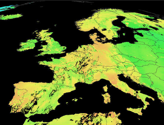
Down-welling surface long-wave flux
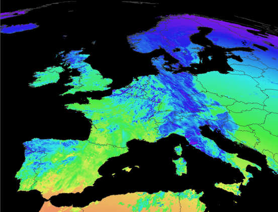
Down-welling surface shortwave flux
Can I register and what do I get?
A licence code is required for this software, after the 30-day
trial period.
Suggestions for future developments are welcome.
| V1.4.2 |
Accept files dropped from Explorer to open
them, add optional timestamp to images, correct missing files from
multiple data sets. |
| V1.4.4 |
Add support for ET (Evapotranspiration) data,
on BZ2 decompress error, exit with error-level in batch mode. |
| V1.4.6 |
Support Fire Risk Map (FRM) data, start Land
Cover (LANDCOV) support (includes colour palette and mouse-over
descriptions, HDF5 cache=0 accepted with reluctance), add ASCII output for
more data types, add image "snapshot" of selected region in
ASCII mode (SNAPSHOT2 and SNAPSHOT4 alternatives provide 2x and 4x zoom),
accept MapGen and GSHHS 2.2 boundary data, add support for local boundary
data which is specified by the environment variable BOUNDARY_DATA,
environment variable BOUNDARY_COLOUR can define the boundary colour
(limited to grey shades currently). |
| V2.0.2 |
Higher precision readout if Ctrl is pressed.
No longer hardware locked to a single PC. Note
that a new licence key is required for this version. If you don't
already have a HDF Viewer 2 key, existing users can upgrade here.
Please state HDF Viewer in the "What product are you upgrading?"
box.
|
-
Download the HDF Viewer V2.0.2 (2015-Aug-09;
1,287,030 bytes)
- MD5 checksum: DA9966612B7396EDA9A36262CB27BA0A
-
Register
the HDF Viewer - please help support continued development
- If you don't already have my runtime Library
Bundle, please download and install it (do this if you get messages
about missing DLLs when trying to run the program).
- For country outlines, you can use the file Countries.dat,
which may already be on your PC or you can download it here
(460KB).
|