|
| |
LRPT Image Processor
Program to add enhancements to Meteor-M N2 images. You may also like my
LRPT reception page which shows the
signal structure, and my Automating LRPT reception
page which gives some hints on using MeteorGIS. The LRPT Decoder
software can now add approximate country boundaries to your image.
Download
 Download the
LrptImageProcessor V2024.03.01.63 (1,200,764
bytes; 2024-Mar-01) Download the
LrptImageProcessor V2024.03.01.63 (1,200,764
bytes; 2024-Mar-01)
MD5 signature: 6695D92F5736EAFC014657D9ECA67B65
Installation
Extract all the files in the Zip archive to a directory /outside/ the C:\Program Files\ tree.
I suggest C:\Tools\SatSignal\LRPTprocessor\ Don't use C:\Program Files as
you may want to edit files in the program's directory. The program has been developed under Windows
8 & 10 but I would expect
it to run on Windows-XP. Operation on earlier than Windows-7 is neither
guaranteed nor supported. It has also worked on Linux/WINE!
Requirements
- Libraries: The program requires my Runtime Library Bundle to be installed,
if you don't already have it.
https://www.satsignal.eu/software/runtime.html
- Keplers: The program requires a source of contemporary Kepler (satellite orbit)
data. You can point the program to an existing source of three line
Kepler data - you only need to give the folder name - or download the Weather
data from the CelesTrak Web site an place the weather.txt file in the
program's folder. You need to keep this current with the data you are
processing, so make the download a weekly one. Special arrangements
apply if you want to reprocess older data.
- Boundary data: To show country boundary overlays the program requires
Kepler data, and a boundary overlay file. A suitable file is included
in the download - countries.dat. If needed, the program can
alternatively accept GSHHS/GSHHG
data.
Usage
The program can remove the edge compression present in the raw scan data from the Meteor-M N2 LRPT data, create a vegetation image, thermal image,
and a false-colour image. The thermal components rely on you saving a 1-2-5 image from the decoder program. In the LRPT offline decoder:
Red => channel 1, 0.5 - 0.7 �m
Green => channel 2, 0.7 - 1.1 �m
Blue => channel 5, 10.5 - 11.5 �m
You can feed the program with a image (BMP or JPG) named on the command-line,
or use drag-and-drop from File Explorer onto the open program, or use the File|Open menu.
Output images are automatically saved as JPG or BMP in the same directory as the input image.
If the optional second command-line parameter "-close" is present, the
program closes after saving the images.
The program has been developed in Embarcadero's Delphi using Windows-8.1 and
Windows-10.
Feedback to the GEO-Subscribers self-help group, please - https://groups.io/g/GEO-Subscribers
There is a page of LRPT reception screenshots using SDR# and QPSK 1.4+ here.
Saying thanks
If you use and like this software, please consider saying "thank you" with a donation. You can make a donation by sending me an
Amazon Gift Certificate here:
https://www.amazon.co.uk/gp/gc/order-email/ref=g_gc-dp_bnow_email
My e-mail for Amazon is: david-taylor@blueyonder.co.uk
Please note that this MUST be sent to the UK branch of Amazon.
Should you prefer to use PayPal, I am: davidtaylor@writeme.com
Release Notes
2015-Apr-24 |
V1.1.0.2 |
Make remapped image display first
Make remapped image auto-centre
Fit to window, left click image to toggle
Adjustable histogram equalisation for infra-red image, right-click the image
to change
Add image hints
Add flip-vertically option for northbound passes
Add Help, About menu |
2015-Apr-24 |
V1.1.0.3 |
Add version number to caption
Rename .exe to LrptImageProcessor |
2015-Apr-25 |
V1.1.0.4 |
Add sharpening & histogram options for false-colour image
Add File|Open menu
Add Option|CLUT menu ..
.. rename default colour lookup table to ..
.. CLUT_1_TempToColourHLS.bmp
.. all CLUTs must be named CLUT_<name>.bmp
.. CLUTs must be 256 x 256 24-bit RGB bitmaps
.. be aware that PhotoShop produces broken .BMP files
Handle drop to program's icon
Improved image centre behaviour on reprocess |
2015-Apr-26 |
V1.1.0.5 |
Add classic RGB124 image
Warn if no suitable colour lookup tables found
Replace flip by rotate 180 |
2015-Apr-27 |
V1.1.0.6 |
Make geometry correction optional |
2015-Jun-18 |
V1.1.0.7 |
Add RGB 122 image
Add setup dialog ..
.. choice of which images to save
.. choice of save format (BMP/JPG/as-input)
.. move geometry correction choice from main menu |
2015-Jun-22 |
V1.2.0.8 |
Revised video-to-temperature calculation ..
.. is improved but still very approximate
.. colours will be different
.. nearer to SatSignal colours
.. approximate temperature displayed in status line
Restore ..
.. histogram equalisation and sharpening options
.. accidentally broken in previous release |
2015-Aug-11 |
V1.2.1.9 |
Add setup option to crispen the saved remapped image |
2015-Aug-13 |
V1.2.2.10 |
Handle very cold IR data better in False Colour |
2015-Oct-07 |
V1.2.3.11 |
Add IR negative image option (right-click) |
2015-Dec-19 |
V1.2.4.12 |
Use mouse wheel to scroll image, shift-wheel to
scroll horizontally. |
2016-Feb-15 |
V1.2.5.13 |
Change mouse wheel scroll direction. |
2016-Dec-29 |
V1.2.6.14 |
Accept "-close" second command-line parameter to exit after processing a file. |
2020-Jan-27 |
2020.01.27.18 |
Narrow down range of .BMP file in the File Open dialog to avoid displaying already processed files.
Alter dialog to distinguish RGB and per-channel files.
Experimental Day/Night mode.
Key ESC closes the program.
Use yyyy-mm-dd-rev version numbering. |
2020-Feb-23 |
2020.02.23.40 |
Add overlays, including station names. Shift with
the cursor keys. Saved with images.
Support 123 files in addition to 122 and 125 files.
Add experimental day/night mode (not yet fully implemented).
Many minor updates, see the LrptImageProcessor.txt file for more
details. |
2020-Mar-01 |
2020.3.1.47 |
Update of day/night algorithm. Fix day/night not appearing when BMP dragged onto icon,
search application directory for palette. Suspect that thermal and vis 0.8 aren't precisely
aligned
so add line/pixel offset options in setup form - applies to False-colour and Day/Night tabs only,
fix Copy-to-Clipboard not working, XOR RGB overlay to greyscale infra-red
image, add Help|Support menu. |
2020-Mar-17 |
2020.3.17.53 |
Accept .STAT files with local decimal separator (avoid 122 etc. composite .STAT files,
warn if .68 etc. files aren't loaded). Better attempt at resolving UTC/Moscow/Japan times?
Add "Processing..." to status bar while busy. Reduce main window initial size, it's not needed.
Don't check Kepler age when using historic Kepler data. |
2020-May-02 |
2020.5.02.56 |
"0" UTC time zone means "0"! Option for red vegetation (RGB211),
accept command-line parameter /out=<directory name> (e.g. <source-file>_65.bmp /out=C:\Tools\LRPT\Tests),
the directory must already exist, the source file must be the first parameter.
Add "Exit" to the image right-click pop-up menu. |
2020-May-07 |
2020.5.02.57 |
Setup option to detect thermal data (if not thermal don't display misleading images
and don't save them). |
2020-Jul-13 |
2020.7.13.58 |
Handle over-long files - spurious data at file end removed,
original file saved as ".copy" rather than ".bmp", updated file saved with
original name, file timestamp not [yet] altered so direction and boundaries will be wrong |
2021-Jun-25 |
2021.06.25.60 |
Allow 30 minute time zone steps. |
2021-Jun-25 |
2023.10.24.61 |
Add Meteor-M N-23 option. |
2023-Oct-26 |
2023.10.26.62 |
Add overlay position tweak options (in the setup form). |
2024-Mar-01 |
2024.03.01.63 |
Add Meteor-M N-24 option. |
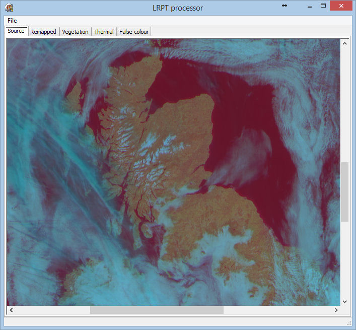
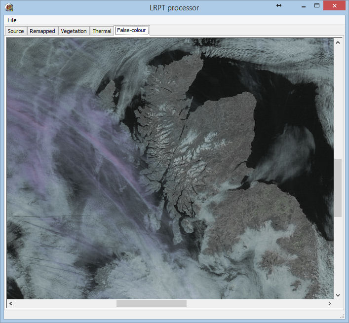
Source image
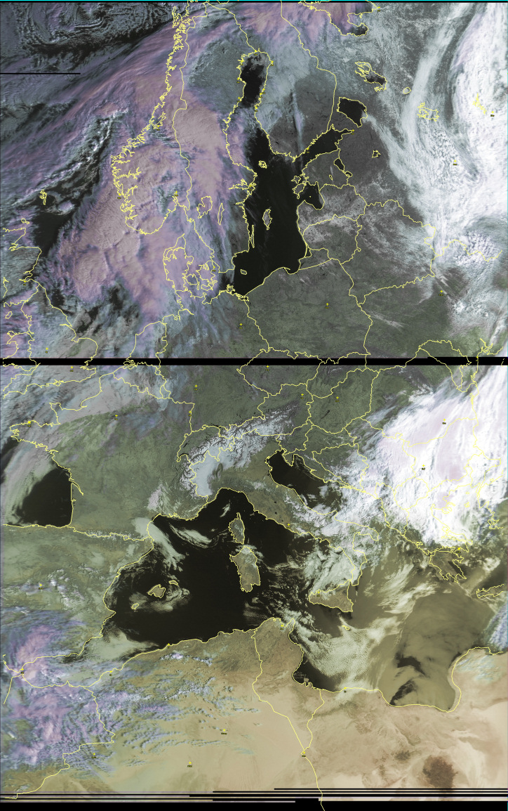
Some screen shots from an earlier version follow, with a larger image and more recent
version at the end of this page showing the country boundaries at work.:
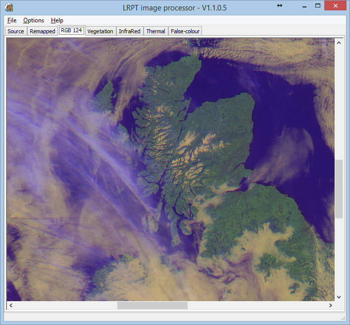
RGB 124 image - a classic combination
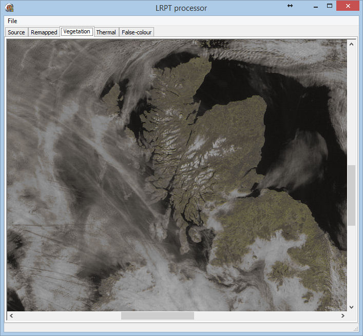
Vegetation image - more green is more vegetated
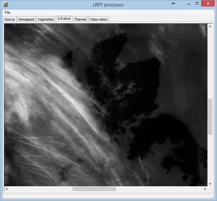
Infra-red image - black is hot
False-colour image - distinguish low & high cloud
An image from data supplied by Peter Kooistra, 2020-Mar-15 at 07:54 pass,
with thanks.
 |