|
| | The MSG Data Manager
What is MSG?
Meteosat-8 (or MSG-1 as it was known during trials) is the
first of the new European geostationary weather satellites. MSG is an acronym for
Meteosat Second Generation. Meteosat-8 (MSG-1) served from 2003 to 2007
AND is now providing Indian Ocean Data Coverage (IODC), MSG-9 is
now the standby Rapid
Scan satellite, with Meteosat-10 providing Rapid Scan, and MSG-11 as the prime
zero degree satellite since January 2013. Meteosat-8/9/10/11 have twelve sensor channels rather than
three, higher spatial resolution, much higher visible channel resolution, better
thermal accuracy, and double the frequency of image delivery than previous
Meteosat satellites; all of which necessitates a change to the data transmission
method. Meteosat-11 (MSG-4) has replaced Meteosat 7, and the WEFAX and PDUS
transmissions have now ceased. The data
from MSG is purely digital, and is delivered as a set of a number of
compressed files per image. As
there are now twelve channels delivered four times an hour, the total data rate
is some 1.5GB per hour, 15000 files per day, requiring significant management on your
computer.
Please note that you will need a licence from EUMETSAT
to receive some of this data, but UK amateurs should see the GEO
Quarterly for more details. They are unlikely to have to pay licence
charges. In addition to Meteosat-9 data and other geostationary weather
satellite data, you will get access to the upper-atmosphere ATOVS
data and Sea-Ice data. These are
processed from polar orbiting satellites and added to the data stream.
What is the MSG Data Manager?
 Download the MSG Data Manager
The MSG Data Manager is a Windows program that will process
the files received from Meteosat-8/9/10/11. These files might be received over the
Internet in the future, but today they are easily received with a Digital Video Broadcasting
(DVB) card installed in your PC, and a standard domestic satellite antenna, LNB,
and cable. A description of my own
system is here. The program can also process data received from the
EUMETSAT FTP service (binary transfers, my FTP
Helper program). The data manager will automatically process the files into
images, and optionally delete the large amounts of source data that would
otherwise accumulate. The program allows you to choose which of the twelve
channels you process to images, and also allows you to keep some raw data in the
processing PC should you wish.
Please note that the MSG Data Manager and MSG Animator are original pieces of
software developed independently by SatSignal Software, Edinburgh specifically
for users such as you, and there is a lot of your input in the programs.
These are not some re-branded programs originally developed by someone
else. You will always get a fast response to the frequent changes made to
EUMETCast data, and not be stuck waiting for the "next version".
More
information about the data flow with MSG.
My demonstration of Receiving and
Processing Meteosat-8 Data with the MSG Toolset Plus suite (which comprises
the MSG Data Manager, MSG Animator and GeoSatSignal) was voted the best of
conference at the 2004 EUMETSAT Meteorological Satellite Conference in
Prague. The judgement was made based upon scientific content, presentation
and overall interest and relevance.
This software has been supplied to the Finnish Meteorological
Institute, Meteo-Swiss, Universities, Museums, and other professional and amateur users throughout Europe.
- "We are very happy with MSG Data Manager: it does what we want, in a
perfect stability" - Michel Albuisson, École des Mines de
Paris.
- "We use the MSG software 24/7 for operational forecasting
information and it allows us to run animations of several channels simultaneously in different windows on dual
displays" - Alan Hisscott, Senior Meteorological Officer, Isle of Man Meteorological
Office.
- "I'm very impressed with the software. When the system was running too
low on hard drive space the data manager stopped updating but nothing
crashed, and the animator continued with old data - very nice! I am
happy to recommend your applications." - Jeff Lashley, UK
National Space Centre.
- "My registration has just arrived for upgrade to MSG Data Manager and also AVHRR manager.
I must admit I'm blown away by it and have just sat down again after dancing around the
room! What have I been missing ah? Awesome."
- Rob Denton
- "Following the recent need for users to activate the MSG-2 data flow, I checked with Ops and they confirmed that since the 'failure' of MSG-1, all users had MSG-2 data enabled.
With David's software MSG Data Manager, all I had to do was change over one setting in the advanced section in order to resume full operations.
David's software has again proved invaluable and exceptionally easy to configure. My grateful thanks, David."
- Lawrence Harris, freelance journalist.
You can use a single PC for receiving and processing
data if the PC is powerful enough, or a two-PC network is supported, with the lower-spec PC
as the Reception PC with the DVB card, and the higher-specification PC as the
Processing PC, grabbing files off the Receiver PC over the network.
You can ask about any particular configuration on the MSG-1
self-help Group, where hundreds users with working systems can help, and there
is a discussion about PC requirements here. Windows-7
or 8 is required for support - older versions
are not supported. I would expect XP/32 and Vista/32 still to
work but I cannot support these versions as I no longer have PCs running XP or
Vista.
Data Volumes
EUMETSAT state that the expected data
volume is around 7000 files per hour (I think that's too high) totalling 540
MBytes. If you take EARS data and RSS data that increases by 44 MB. Therefore a full day's data would be about 15GB. If you
keep all 12 MSG channels, but save the images as JPEG not PNG, the saved
images amount to 1.1GB per day in 1152 files. Of course, if you take
all the FSD (Foreign Satellite Data) as well the volumes can increase massively,
up to a total of some 500 GB/day.
What functions does the MSG Data Manager have?
- Can work on the same PC as data reception or on a different
networked PC
- Automatic monitoring of the Reception PC for the presence of
new files.
- Automatic copying of those files from Reception PC to
Processing PC
- Optional deleting of raw data files on the Reception PC
- Selection of which channels to process, reducing the
subsequent processing and storage requirements
- Processing includes both HRIT and LRIT Meteosat
SEVIRI data
- Processing includes both Meteosat-5 and Meteosat-7
data
- Processing includes MPEF, MDD, GTS and DCP data
- Decompressing of the data files coded in JPEG and Wavelet
Transform formats
- Data reduction from 10- and 12-bit source data to 8-bit
display data
- Fully calibrated 10-bit data saving (PRO version only)
- Real-time thumbnail display of selected channels as data is
received
- Optional gamma-correction, gain and offset processing for
visible channels
- Temperature calibration of infra-red channels
- Saving of processed data in standard image formats
- Choice of PNG for full precision or JPEG for disk economy
- Management of HRV region selection (offset and
northern-area)
- Local display of multiple detail images at full resolution
- Histogram
equalisation and false-colour palettes for detail images
- Histogram display of 10-bit received data (PRO version
only)
- Management of received data - older data can be
automatically deleted
- Display of Admin messages sent over the data stream, also
saved as text files
- Copying of Sea-Ice data for further processing
- Copying of [Data Channel 1] ATOVS and RSS data for further
processing
- Optional program priority drop when CPU-intensive
operations are underway
- Optional sound announcements at start and end of scan
- Optional alert on data loss - you can send
yourself an e-mail!
- Graphical display of scan progress
For an extra charge, you can also get the MSG Data Manager PRO
version. This is aimed primarily at those doing research, where it is
important to be able to access the full 10-bit data, rather than have the data
converted to 8-bit images. If you are writing your own software for
processing MSG data, the PRO version is probably what you need. Extra functions in the PRO version include:
- The ability to save raw 10-bit data in PGM files from
Meteosat-8/9/10/11, and
full-precision data other satellites
- Calibration data is saved in the PGM files as well,
allowing the recovery of radiance values
- Eight "Detail Image" displays (versus four in the
standard version)
- A right-click, Histogram Display function for the thumbnail
images
- A right-click, Histogram Display function for the detail
images
- The ability to choose the save format (default, JPEG or
PNG) on a per-channel basis
If you wish to process the images further, for example to make
false-colour combinations, remap to standard map projections, or to animate the
images, you could consider my GeoSatSignal program.
For purpose-built real-time animations, without colour or rectification to
standard mapping, my MSG Animator program is the tool
of choice.
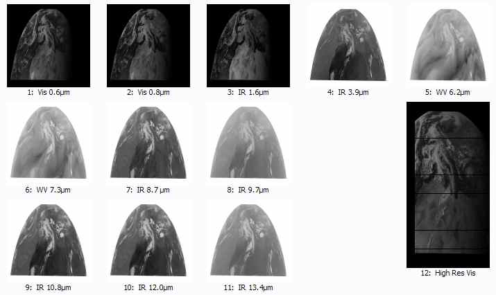
What data does the MSG Data Manager process and display?
| Image data - processed and
displayed |
| Meteosat-8/9/10/11 HRIT image data |
11 channels at 3km resolution
1 HRV channel at 1km |
Displayed in MSG Data Manager |
| Meteosat-8/9/10/11 LRIT image data |
5 channels at 3km resolution |
Displayed in MSG Data Manager |
| FY-2C/D/E/G data |
6 channels: 2 x visible, 3 x IR, WV
1 visible channel at 1 km |
Displayed in MSG Data Manager |
| Himawari-8 image data |
13 channels can be processed |
4 channels displayed in the MSG Data Manager |
Non-image data - processed only |
| Reception of some of this
data may require an extra EUMETSAT licence |
| MPEF data |
Multiple data types |
Some data viewable
with the GRIB Viewer |
| DCP data |
Multiple data types |
|
| DCP/WMO data |
Multiple data types |
|
| MDD data |
Multiple data types |
|
| MDD/GTS data |
Multiple data types |
|
| OSI SAF Ocean and Sea-Ice data |
Multiple regions |
GRIB data viewable with GRIB
Viewer software
Specialised Sea-Ice and SST viewer
available |
| LSA SAF Land Surface Analysis data |
Multiple regions |
Some data viewable
with the HDF Viewer |
| ERS/SCAT scatterometer data |
|
Wind data view with BUFR
Viewer |
| ATOVS data |
From polar orbiters |
L1C and L1D visualised with the ATOVS
Viewer |
| BMD data |
Multiple data |
Some data viewable
with the GRIB Viewer |
| DWDSAT
data |
Multiple data |
Some data viewable
with the GRIB Viewer |
| MODIS
Wind data |
|
Wind data view with BUFR
Viewer |
MSG Data Manager Operation
The program first copies data received by the DVB system from the
Receiver PC to the Processing PC, and optionally deletes it from the receiver PC.
You can select which channels are to be deleted, and which copied for processing. As the satellite scan proceeds, you will see the images build
up from south to north, and once an image is complete it will be saved to disk. Visual channel images are JPEG compressed, and thermal channel images
PNG compressed (lossless).
You can use the Windows Control Panel to select sounds to be played at the start and end of a scan (specifically when the Prologue and Epilogue files
are processed).
The program is intended to be left running continuously, copying and processing the received data.
MSG Data Manager Screen Shots
Here are some screen grabs from a recent version of the MSG Data
Manager.
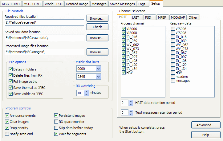
The first thing you need to do on getting the program is to
tell it where to look for the files from EUMETCast, where on the processing PC the
raw data is to be stored, and where the processed images should live. Note
that both of these latter directories will use an addition year/month/day naming
convention for the folder names so that the number of files per directory is
kept at a reasonable level.
You can then set a number of other options, in particular which channels are to
be processed and what should happen to the raw data.
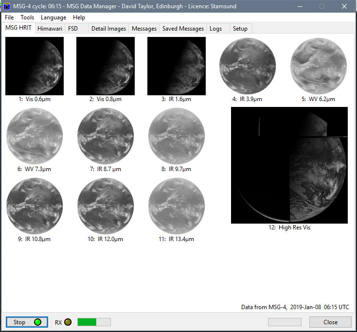
Once setup is complete, you press the Run button and switch to the
MSG HRIT tab, where data from all the selected channels builds up. During the operation of the program, you will see the scan
build from South to North. Any gaps at the top of the images are there
because that part of the earth has not yet been scanned. Watching the
pictures build like this is fun! The channel spectral region will pop-up as your
mouse moves over the thumbnail. Note that the last image, that of channel 12, is not
square like the others, but has a 2:1 aspect ratio. It is over 11000
pixels high and over 5000 pixels wide! The imager on the satellite can be
adjusted to cover different parts of the Earth on the north and south parts of
the scan. Here you see it almost centred on Europe in the northern part of
the scan, but centred on Africa for the majority of its scan. The program
centres all the data to make the composite
picture. The scan position is altered from time to time, as shown in this 2MB
animation from EUMETSAT.
Click on the image below to see an animation of the MSG Data Manager at work!
Click for an animation (from an earlier release)
The FSD (Foreign Satellite Data) tab shows the LRIT data
relayed from satellites around the globe. Data from GOES-15 and GOES-16/17
is now handled by new programs: GOES-15
netCDF Manager and GOES-16/17 ABI Manager.
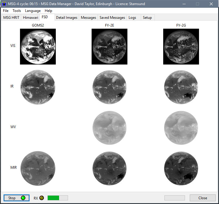
(screen shot from beta program version)
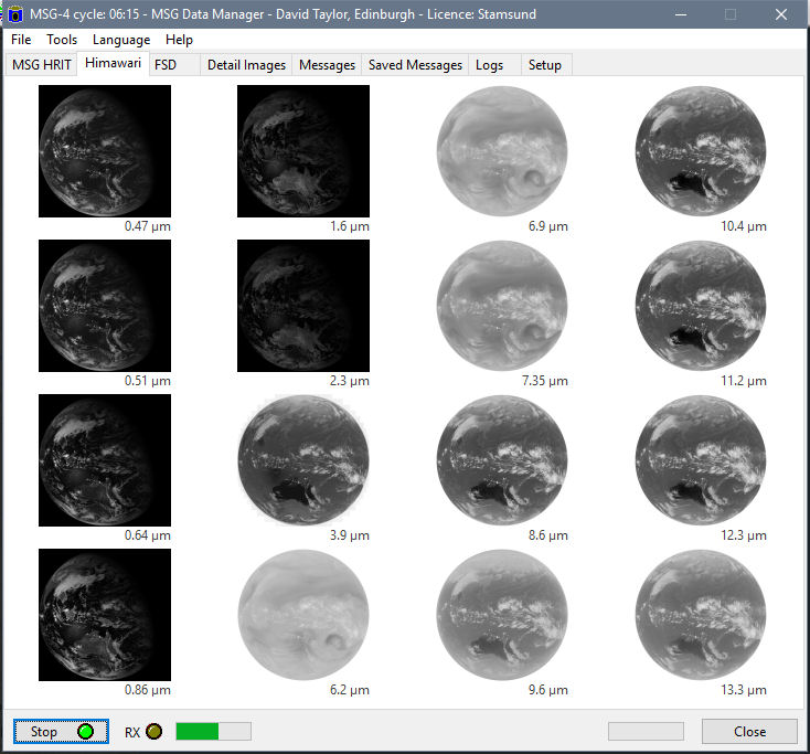
The new Himawari tab shows all 16 channels from the Himawari-8
satellite over Japan and Australasia.
From the Detailed Image tabs
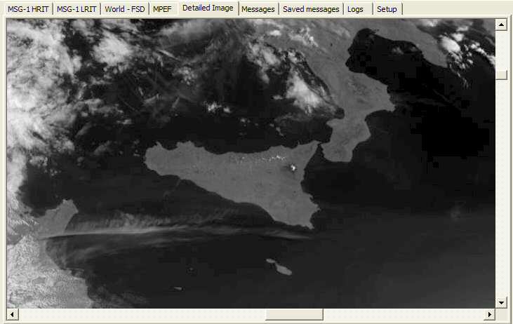
On 2004 May 27 at 08:15 UTC I selected channel 12 by clicking on the image, and then moved
the view to the are around Sicily and mount Etna. The snow-covered peak of
Etna and the darker volcanic soil around Etna are both easily visible. The
islands of Gozo and Malta are visible to the south of Sicily. All these
images are from EUMETSAT data.
More recent versions of the MSG Data Manager allow multiple
Detail Image pages, and allow the detail images to be coloured with your choice
of visible or thermal palettes (Colour Lookup Tables or CLUTs). On the two
images below, note how the low fog-like cloud off Norway and the southern coast
of the UK stands out well in the visible channel, but not in the thermal channel
with the particular LUTs in use. (I show the PRO version of the MSG Data
Manager below. This has eight detailed displays versus four with the
Standard version).
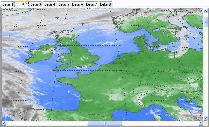
Channel 9 Meteosat-8 data with ZW colour enhancement
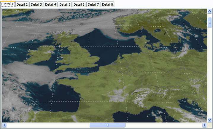
Channel 2 Meteosat-8 data with pseudo WEFAX colour enhancement
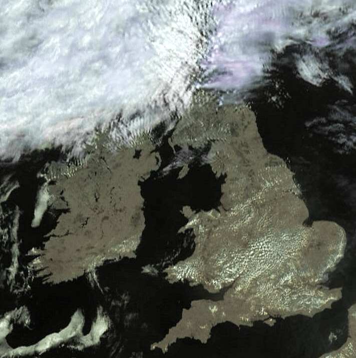
On May 18th, 2004, much the UK and Ireland was clear of cloud. Here is an
HRV (channel 12) image from Meteosat-8, rectified to orthographic projection in GeoSatSignal.
False-colour is achieved by using data from the 10.8µm thermal channel.
In May 2008 EUMETSAT started a Rapid
Scanning Service which uses the MSG-1 (now MSG-2) satellite now located at 9.5° East to
provide a new image of North Africa and Europe every five minutes. This
provides considerable improvements for "nowcasting" and of course can
produce superbly smooth animations! To achieve the fast scan, only the
northern-most part of the globe is scanned, resulting in just three image
segments being transmitted (and nine for channel 12 HRV). To distinguish
the rapid scan mode of operation, and to provide a slightly more detailed view
of Europe, the MSG Data Manager will provide a stretched display of the
thumbnails when operating in rapid Scan mode. You can read
about running two copies of the MSG Data Manager, one for normal scan and
one for rapid scan, in the FAQ. The screen display will appear as shown
below. Do you like this mode? Of course, the Detail Images and the
saved images retain their correct shape and can be processed as normal - it is
only the thumbnail display which has this distinctive appearance to show that
RSS is being received.
The special appearance of thumbnails in HRIT/Rapid-Scan mode
How do I get the MSG Data Manager?
- You can purchase
a licence for the MSG Data Manager
online.
- You can try the program before purchase by downloading
the program below, as it has a built-in 30-day trial licence. At the end of your trial period, you will need to either stop using the software or
purchase a licence.
- Please note that Windows 98, 98SE and ME, NT 4, and 2000 are not supported,
and whist the program may function, some error messages may occur because
these operating systems have trouble supporting the very large image sizes.
- There is a bundled
offer of the MSG Data Manager, the MSG Animator
and my GeoSatSignal
software in the MSG
Toolset
Plus package, which is a very economical way to purchase.
This software has been supplied to the Finnish Meteorological
Institute, Meteo-Swiss, Swiss, Italian and Spanish TV, Weather Services,
Airports, Universities, Museums, and professional and amateur users throughout Europe.
| V3.1.6 |
CRM report changed to 12:00 for zero-degree
data, merge several "all missing" reports into one report line,
update reporting for Met-7 final decontamination, prepare reporting for
Met-7 switch-off on 2017-Mar-31, improved efficiency in purging older
files (separate LSA retention option removed - use SAF retention instead,
separate CRM retention option removed - it's now a daily file - use MPEF
retention instead), auto-restart updates (please note this is not intended
for routine use in normal circumstances), prepare for HL-L2-SST_IST-METOP
data, support Himawari 9.6 µm data on channel B12, add detection of
TelliCast 2.14.2 client for priority drop, update for new IASI L2 file
names on data channel 1, correct naming of FY-2E data in report, correct
boundaries when saving IODC images, correct channel name hint for CMA
data.
|
| V3.1.8 |
Add GOMS-2 support (replaces GOMS-1 support,
can save pro/epilogue files if requested, improved visible channel
scaling), support NOAA Direct Broadcast (NDB) data, support SMAP level 1C
data, support NPP Active Fire product on data channel 12, honour MPEF/OCAE/parallel
purge, update for new EARS sounder file names & .NC files included in
retention purge, support more BMA-RA files, remove some retired
satellites, updated reporting options (add FY-2G switch, retire Met-7
etc.), more efficient purging (updated in .1264) - experimental, please
check carefully!
|
| V3.1.10 |
Update for new NPP-2 file names
|
| V3.1.12 |
Add decoding of Alert and Weekly Schedule XML messages, support KNMI OSI SAF ScatSat data, support new H-SAF file names, blind support for NOAA-20 NPP-2 data including purge of older data, start 10-minute, 16-channel Himawari-8 support, new Himawari tab, add bands B01 and B02, can be saved as .PNG, determine Him-8 cycle directly from filename, add "Reset all retentions" option (useful when configuring multiple instances), update reporting (skip GOES-15 after 2018-Dec-31, remove some obsolete stuff, skip 02:40 & 14:40 Himawari-8 "unloading" routine events, 16-channel support, enhanced RSS/no-MPEF detection), save logs hurly on Himawari-8-only instance, support GOES-15 at 128W including boundaries on both thumbnails and saved images, faster response for MSGSCANEND notification for RSS (15 seconds rather than one minute), update program's title when Himawari data received (then to MSG if present), reduce housekeeping frequency, Help|About supports longer file
names, add Help|Support menu.
|
| V3.1.14 |
Start FY-2H support at 79 East, new image file names like:
201906140500-fy2h-Vis.png, support changed NWC data, support changed S-OSI_-NOR...
files, improved reporting when multiple RII missing, skip MPE reporting
after 2019-Jul-10, improved recognition of RSS without MPEF, enhanced
collation of multiple missing cycles, support new E1B-SAF data channels.
|
| V3.1.18 |
Start GOMS3 support (image files labelled
"GOMS2" as the projection is the same, not happy with IR4 data),
reduce "Not responding" Task Manager messages, include TPC-1 in
120-day empty directory trim, start FY-2G solar eclipse report a little
earlier, remove reporting for discontinued prime 0° & IODC level 2
products, reporting updates for AMV slot changes, neaten multiple missing
MPE slots, remove discontinued TOZ products.
|
| V3.1.20 |
Works with the new channel names (added WaveWatch on channel 8), language files updated, IODC data recognised with output to MSG-IODC and MPEF-IODN (45.5°
E) directories, stale data and directory trim honoured for Marine and Atmos processed data, auto-update to MSG Animator confirmed, some non-standard named SatWind files recognised and put in the yyyy\mm\dd tree.
NB: you may need to enter your registration again but without
using Run as Admin.
|
| V3.1.22 |
Honour retention period for MPEF-IODN
data, restore empty directory scan for MSG-IODC data, correct save of
zipped FY2G/H images (unzipped not possible, side-effects on CMA met data
not checked), update reporting for end of CSR data, store LSA-SAF H60 and
H60 in correct yyyy\mm\dd directory, start work on new format MPEF names
(MPEF files saved as MPE, option to retain raw MPEF files in temp tree,
bug fixes & enhancements).
|
|
Note: If you don't already have an MSG Data Manager 3
key, contact me to purchase a licence update key before using this
software. You can upgrade either just the MSG
Data Manager, or the three programs in the MSG
Toolset Plus (the MSG Data Manager, MSG Animator & GeoSatSignal).
|
Beta version: This program is under continual
development - check here
for the latest update.
Important: The MSG Data Manager includes a 30-day trial licence. Please
wait until you have data to test before installing the program, as the
30-day countdown starts from the first time the program is run!
This program requires
a display size of at least 800 x 700 pixels.
If you are interested in MSG data, did you know that with the
same EUMETCast reception hardware you can now get high resolution AVHRR data
from the polar orbiting satellites such as NOAA-19 and Metop-A and Metop-B I
have software for these EUMETSAT options in my AVHRR
Manager, DWDSAT HRPT Viewer, and my Metop
Manager.
The MSG Animator provides real-time animation of images from
Meteosat Second Generation and other weather satellites received with the MSG Data Manager.
It is dedicated to EUMETCast data. If you want false-colour animations with geographic
re-projection and weather chart overlay, please look at my
GeoSatSignal program.
Download the MSG Animator
Program highlights
- Multiple simultaneous, independent animations, updated in real time as new data becomes available
- Selection of channel and graphical selection of region subset, with country boundary overlay
- Animation of Meteosat-7, 8, 9 & 10, MTSAT-1R, & GOES-E
& GOES-W data providing
world-wide coverage
- Looping and smoothing of animations, with optional histogram and contrast stretch image-processing functions
- False-colour option with land/sea separation and dark-cloud
tops
- Control over animation length with option to choose visible hours only
- Save an animation in standard Windows AVI format
- Kiosk-mode operation for interactive public displays and
museums
- Automated animation switching for reception areas etc.
- Can work remotely from the MSG Data Manager over a network
(requires the runtime Library Bundle to be
installed on the PC where the MSG Animator is to operate).
- Windows-7 or Windows-8/8.1 is required. The earlier
Windows XP/32 and Vista/32 versions are not supported.
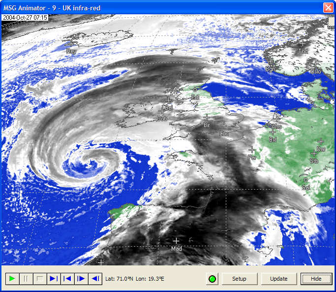
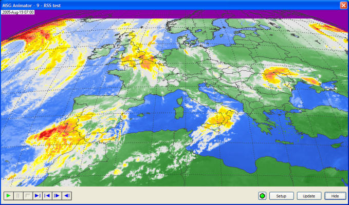
Sample animations
Here are some sample still screen-shots showing the MSG
Animator in action. You can use thermal channel, water-vapour channel or
visible channel data as the source of the animation and, by using colour look-up
tables, this date can be made easier to understand.
Getting the MSG Animator
| V3.0.2 |
Allow user choice of animation root path,
allow max frame in day to be the 23:55 UTC.
|
| V3.0.4 |
Start support for direct MTSAT-2 HRIT data
(allow MTSAT-2 HRIT to accept the full disk option, increase maximum
height and width to 11008 pixels, correct meridian for direct MTSAT-2, add
new land/sea masks for 1 km and 4 km data), start support for Himawari-8
data (all channels supported, includes land/sea mask for 2 km data), list
channels in alphabetic order on Setup dialog.
|
| V3.1.2 |
Recognise MPE as different when full-scan or
rapid-scan, start support MSG IODC data (use correct Land/Sea mask for
northerly animations).
|
| V3.1.4 |
Update for MSG/full land/sea mask.
|
| V3.1.6 |
Support for GEOS-16 at 75° W, updated for
10-minute GOES-16 animations, support GOES-15 at 128° W, support for
GOES-17 at 137° W, support FY-2H at 79 ° E, start 10-minute
Himawari-8 support, earlier start for Himawari, support new MPE
replacement hydrology (files named like:
S-HSAF-h03B_20190723_1130_fdk.grb, need to set Unzip SAF in the MSG Data
Manager, need to use timer updates, not from MSG DM, there are 48 * 19 MB
files/day => almost a GB!, experimental! Restore support for FIRE
animations, file format may have changed. More natural frame rates
for 60 Hz monitors (you may need to rebuild your animations). You
may need to copy land/sea masks from the beta GeoSatSignal directory.
Remove obsolete satellites from channel list, use F5 key to trigger an
animation update.
|
| V3.1.8 |
Support 10-minute GOES-17 data, cities on zoomed animations, option for always-on-top ("-OnTop on command-line)". Faster start-up - you may need to enter your licence key again, but this time NOT using Run as Administrator,
support MSG/IODN data and auto update from the MSG Data Manager.
|
Beta version: This program is under continual
development - check here
for the latest update.
Visit the SatSignal
self-help group to discuss this software with other users
Specialised software
In addition to the software listed on this page, I have a
number of other software packages for processing Meteosat-8/9/10/11 data including MSG
to GeoTIFF
for converting the data to radiance, brightness-temperature and reflectance and
saving the results as GeoTIFF files, and the MSG Fire Tracker for detecting
fire hot-spots using a multi-channel algorithm and reporting the results up to
an FTP server. Please contact me if you are interested in this
software. I can also supply readers for the EARS ATOVS
data, the Sea-Ice
and Sea-Surface Temperature (SST) data, and the GRIB data
from EUMETCast MPEF and DWDSAT data broadcast over the DWDSAT
service.
Fire detection with Meteosat-8/9/10
For example, here is a sample screenshot from the MSG Fire
Tracker program. Using Meteosat-8 data from 07 August 2005, fires have
been detected in North Africa, Spain, Portugal and the south of France.
The detected fire pixels are highlighted by yellow rectangles in the image
below.
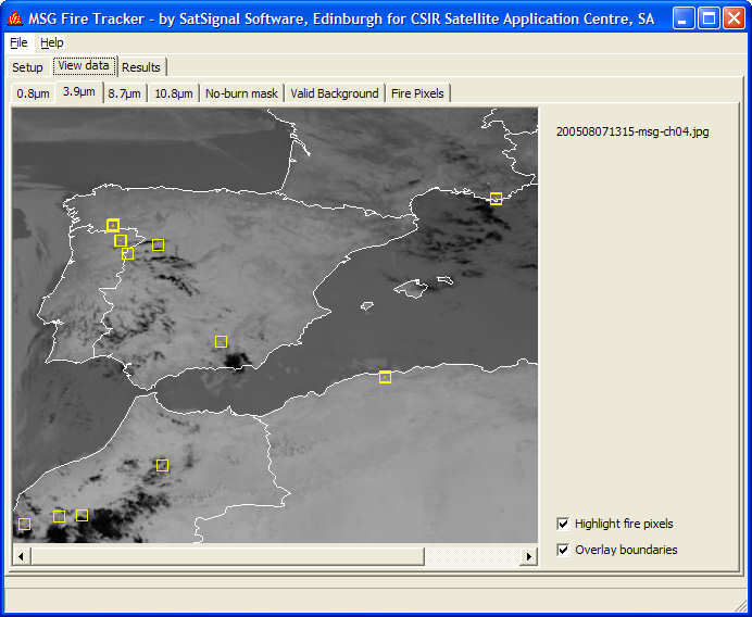
Sample screenshot from the MSG Fire Tracker program
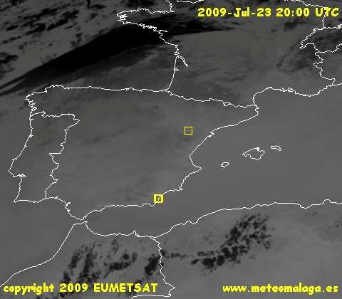
Here's another screenshot from 2009 Jul 23 showing fires in
Spain. My thanks to Harry at http://www.meteomalaga.es.
You can see Harry's current data here.
Some data sources such the EUMETSAT Archive (MARF) provide MSG
HRIT segment files which can be processed with the MSG Data Manager, but the
timestamp on these files is either incorrect or becomes lost when transferring
between the source and your PC. The MSG timestamp program is a very
simple, free utility which will timestamp MSG HRIT according to their file
names, so that they will process in their natural order. This is useful to
allow the MSG Data Manager to process these files, and may help other
manufacturer's software as well. This is a free utility.
Sample images from Meteosat-8 (MSG-1)
Guidelines on publishing
EUMETSAT data
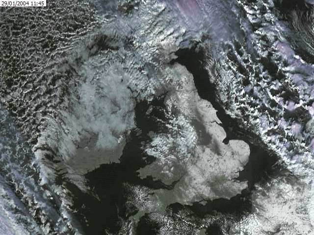
UK Snow - January 2004
This image was from January 29th 2004 after extensive
snow-falls in the UK. The high-resolution visible channel (HRV) has been
combined in GeoSatSignal with thermal information
from the 10.8µm thermal channel to make a false-colour image, which has then
been rectified to a polar-stereographic projection.
Image copyright EUMETSAT 2004.
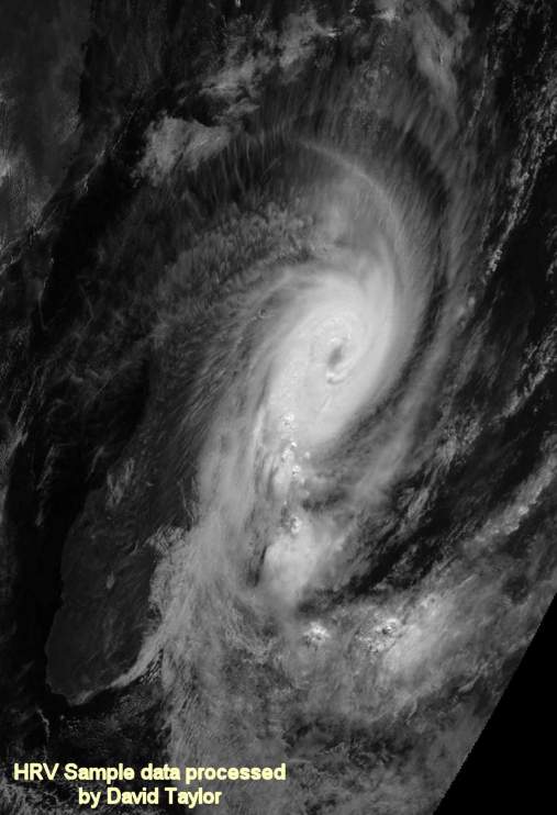
Tropical cyclone Manou - May 2003
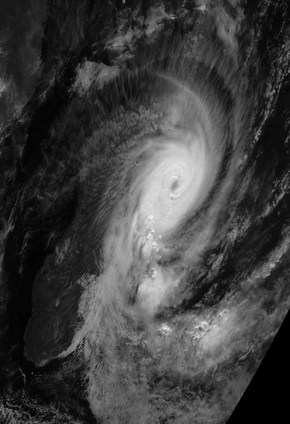
Here is an image taken during the trials of EUMETSAT's MSG-1. It show tropical cyclone Manou off Madagascar. It was
processed by the MSG Data Manager and Paint Shop Pro. Image taken 2003 May
08 at 0744 UTC. Click
for a full resolution version (130KB). Note that the image is near the
edge of the field of view, and there appears slightly squashed. The HRV channel
provides images in the visible waveband, 11136 pixels by 5568 pixels.
Image copyright EUMETSAT 2003.
Click the image for a full-resolution version
Other data from your EUMETCast service
In addition to the Meteosat-8/9 and other geostationary
weather satellite data carried on EUMETCast, you will also have access to Sea-Ice
concentration, sea-surface temperature data, and ATOVS atmospheric sounding
data. I can provide programs which decode and display this data if you are
interested in these aspects of the weather. Here are some sample images to
whet your appetite....
Sea-surface temperature sample data
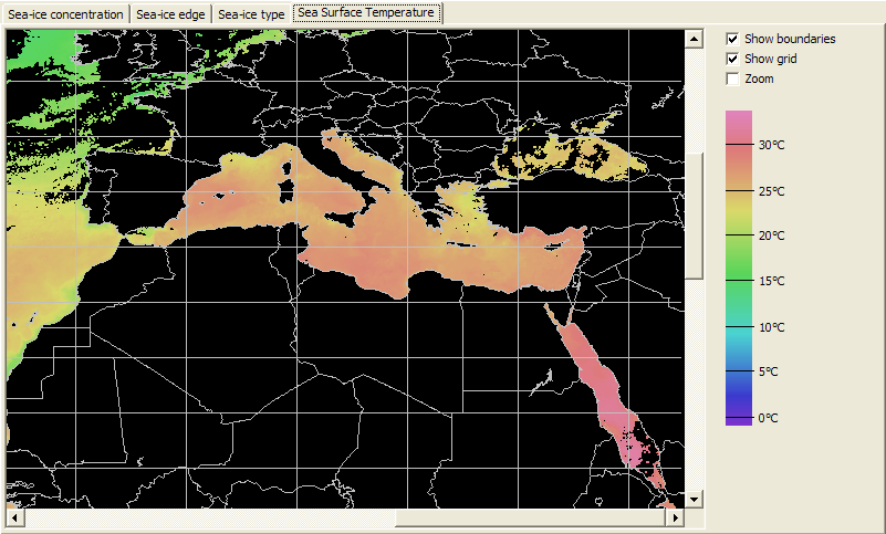
Sea-surface
temperature sample
data
Sea-Ice sample data
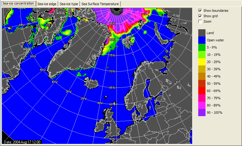
Sea-Ice sample
data
ATOVS sample data
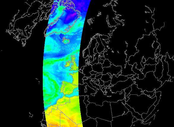
ATOVS sample data
|


