Fire in the South of France - 2003 July 17
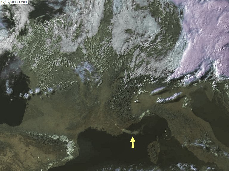
ProcessingThis image was acquired and the channels processed by the MSG Data Manager software. Channels 12 (high resolution visible) and channel 9 (10.8um thermal) were combined in GeoSatSignal4 to produce the false-colour image above, which was rectified to remove the distortion introduced by the slant view from a geostationary satellite. Data from 2003 July 17 at 17:00 UTC. The smoke from the fire is shown by the yellow arrow. Cold cloud tops (purple) and cloud shadows are clearly visible on the eastern part of the image. In the channel 9 image (not shown), the hot spot caused by the fire was clearly visible, even though the spatial resolution of that channel is only a third of channel 12. ReportThe next day, Alan Sewards wrote to me: "That was quite a fire. It is now more or less under control, having run down to the sea. It burnt 6000 hectares, travelled 30 km, and destroyed 40 vehicles, 5 bungalows and 3 houses. As I write, the water bombers are still going back and forth, presumably to ensure that it is really out along the way. There were 1300 firemen working during the night, and now many roads are blocked by lines of fire engines, so traffic is all snarled up. We were far from damp and foggy, as it was 35C yesterday with 19% humidity, add the wind gusting to 50 km/hr and you can see why the fire spread." And he later wrote: "The fire was not out or under control at all, and
continued for a further 24 hours before it was, on Friday evening. In the end it
destroyed 9000 hectares (that is 90 square kilometres!) and travelled 40 km, 30
towards the sea where it had to stop, and ten north when the wind changed on
Friday. The fire front travelled at up to 4 km/hr at times and averaged 2
km/hr. Miraculously no people were injured, although of course tens of
thousands of animals must have died. The fire ran through several camp
grounds along the coast and completely destroyed them, caravans, cars,
bungalows, the lot. In the end 3 houses, 5 bungalows and over 50 cars were
destroyed as well as mobile homes and caravans. 6000 people were
evacuated, many during the middle of the night and power cuts affected up to
40,000 homes (including ours!). Strangely, the fire was very similar to
the last one in this region in 1990 and followed almost the same track, which
fact is giving rise to a lot of finger pointing. AcknowledgementsMany thanks to EUMETSAT for making access to MSG-1 trial data possible, and to Alan Sewards for his on-the-spot report. |