WXtrack Extras for Registered Users
Satellite status pop-up
 A Satellite Summary form is available by right-clicking the World Map display - includes MA display, nearest city in addition to azimuth, elevation range etc. |
GPS Prediction Mode
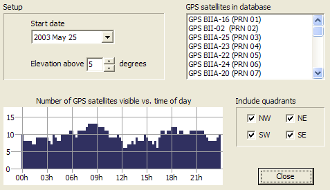
(Note that the quadrant selection check boxes are only available in V3.4.0 onwards.) |
"Radar" mode extras
|

Tracker testing options
Use the Z and X keys to toggle a preset offset allowing you to confirm that a dish is correctly positioned. |
Point at a specified azimuth and elevation, and track the Az/El values if you want. |
Point at a specific position in the sky and optionally track the requested position. |